


The Target Area
It's CHASE DAY! It's the day we live and prepare countless hours for so you can have the best storm chasing tour experience available! Our goal is tornadoes and to find them we have to be in the right spot, but many ask what does it take to be on the right storm at the right moment? On this page, we will go over what typically goes into a chase day that you will experience during your storm chasing adventure tour. Understanding meteorology, excellent forecasting ability and having a chase strategy is critical to our success. Let's dig a little deeper first to get an understanding.
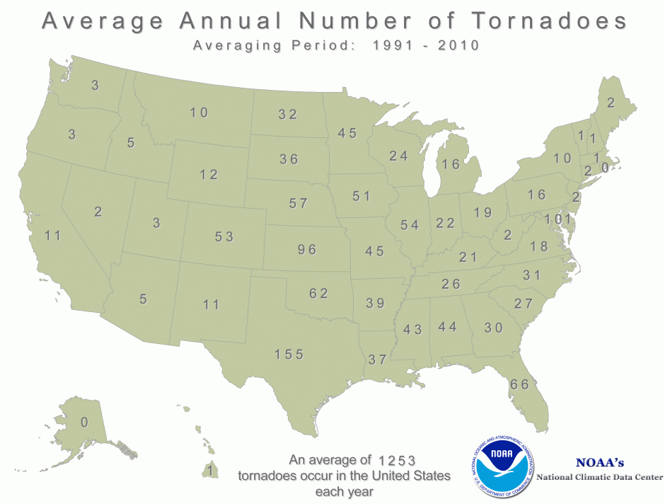
Tornadoes are actually pretty rare, with most tornadoes lasting less than 5 minutes. On average in the United States, about 1,250 tornadoes occur every year. The highest occurrence of tornadoes are in Tornado Alley, but other states outside of this region also have tornadoes when the conditions are favorable. This now cuts the number of "chase-able" tornadoes in half. On average 100,000 thunderstorms occur in the US annually and a very small percentage of those are supercell thunderstorms and about 20% of those supercells produce tornadoes. So how in the world do we find such a rare event in such a big area? Science and forecasting!
Before and during your storm chasing tour we are constantly forecasting using Numerical Forecasting Models. These models take samples of real data from weather stations and weather balloon soundings. A series of large supercomputers then calculate the data into what it believes the atmosphere will do in the future. It is up to us ( the forecaster) to interpret this data. It is never to be fully trusted and an analytical mindset with a touch of intuition is needed to come up with a forecast. There are many of these computer-generated models, each with their own bias and use. We compare the output from the different models to see whether or not there is agreement or disagreement on the outcome of an event or if the event will even take place. For example, one model could be showing a tornado outbreak over the Texas Panhandle and the other shows a rainy day with a much lower chance of severe weather. There are long range, medium range, and short-term model guidance. On a tour, you will hear us talk about things like GFS, NAM, NAM4K, Euro, HRRR, RAP. These are all different numerical forecasting models each with their own purpose. Think of them as tools in a toolbox.


NAM (North American Mesoscale Model) Numerical Forecast Model shown above, depicting a potent trough 24 hours in advance that brought a rare November tornado outbreak to the Texas Panhandle and Kansas on 11-16-15 (Shown right)


Our forecast paid off with 6 tornadoes observed near Pampa, Texas 11-16-15
As the potential chase day nears we continue to monitor the evolution of the models and their trends. We are now 24 hours from the big day, models are still being used as part of the forecast but now real data comes into play, surface observations, satellite imagery, weather balloon soundings. This real data is now compared to the numerical models. This helps us as forecasters to see which model is on track to being correct and which one could be the outlier. Typically by this time, we have a preliminary target area where we expect supercells to develop. Continuing to observe real data is key for the next 24 hours.


Visible Satellite showing a large Supercell in central Texas. 06-11-2009
Image below is of the large HP supercell

The target area we pick is off of a collection of information based on numerical models, leading down to short range models and real data from satellite, surface observations, and weather soundings. Off this information, we pick the area that has the greatest potential for supercells and tornadoes. On the day of the chase, we follow mesoanalysis, visible satellite and weather observations. This type of forecasting is called nowcasting. Once in the target area, current observations play a huge part of where our next move will be. If our target area is correct we won't have to move very far for the start of the show, if its off then adjustments are made in position to get back in the game. The target area can also be picked based on storm chasing strategy!
If there are two areas of potential within a reasonable distance we will position ourselves to where we can be within the range of both areas and see which one plays out.
After all this data has been looked over, moisture is on track moving northward from the Gulf,
a powerful trough is digging, a triple point is setting up and mother nature sets the stage for what could be an amazing day! You arrived the day before and your storm chasing tour guide has you wake up early the next day for your first storm chase! In the lobby of the hotel we go over a synopsis of the day's storm chasing potential, the target area is picked out and soon we will be on the road for what could be an amazing day of chasing! After a few hour drive, we arrive at the target, we are still utilizing real data and watching radar closely for supercell initiation. In the distance, towers of cumulus clouds begin to rise upward as forcing pushes them upward through the cap. We are in perfect position. The newly developed storm is just to our south-west and maturing rapidly as we wait with anticipation! As the storm nears, a wall cloud develops and begins to rapidly rotate! With excitement growing, a tornado touches the ground! Everyone cheers and celebrates! A new memory made in tornado alley, one that will never be forgotten! This is what we do, it is what we live for. It never gets old!
As you can see there is much to understand when it comes to pinpointing a location for tornadoes. With our storm chasing tours we will educate you on supercell formation, the "ingredients" needed to produce supercells and tornadoes, basic forecasting and much more! We promise you will be impressed with our knowledge, forecasting ability and chasing!
We look forward to having you come out with us next storm season!